Cookies op Kieskeurig.nl en de overige Reshift websites
Wij maken gebruik van cookies, en dit doen we:
Voor functionele en analytische doeleinden.
Om relevante advertenties te tonen.
Om te zorgen dat je kunt inloggen met je account.
Om onze dienstverlening te verbeteren voor onze gebruikers.
Om te zorgen dat Kieskeurig.nl gratis is en blijft.
Wil je meer weten over het gebruik van cookies en hoe wij hier mee omgaan. Lees dan onze complete privacy statement hier.
Waarom moet je eigenlijk akkoord gaan met cookies?
Cookies zorgen ervoor dat wij bepaalde functionaliteiten kunnen aanbieden aan onze gebruikers en onze klanten. Kieskeurig.nl is altijd al een gratis dienst voor en door gebruikers geweest. Om te zorgen dat we Kieskeurig.nl gratis kunnen houden tonen wij bijvoorbeeld advertenties. Cookies zorgen ervoor dat jij als gebruiker advertenties krijgt te zien die relevanter voor je zijn. Daarnaast zorgen cookies ook voor inzichten in hoe onze site presteert. Hierdoor kunnen we onze site blijven verbeteren.
Wil je meer weten over het gebruik van cookies en hoe wij hier mee omgaan. Lees dan onze complete privacy statement hier.
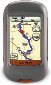
Dakota 20 Outdoor navigation meets touchscreen simplicity in Dakota 20. This rugged, palm-sized navigator combines touchscreen navigation, high-sensitivity GPS with HotFix satellite prediction, barometric altimeter, 3-axis electronic compass and microSD card slot in one affordable, power-packed punch.
Touch and Go Dakota 20 makes outdoor navigation effortless with a tough, sunlight-readable, 2.6 inch colour touchscreen display. The interface is easy to use, so you’ll spend more time enjoying the outdoors and less time searching for information. Both durable and waterproof, Dakota 20 is built to withstand the elements: bumps, dust, dirt and water are no match for this rugged navigator.
Get Your Bearings Dakota 20 has a built-in 3-axis electronic compass, which shows your heading even when you’re standing still or not holding the device level. Its barometric altimeter tracks changes in pressure to pinpoint your precise altitude, and you can even use it to plot barometric pressure over time, which can help you keep an eye on changing weather conditions. And with its high-sensitivity, WAAS-enabled GPS receiver with HotFix satellite prediction, Dakota 20 locates your position quickly and precisely and maintains its GPS location even in heavy cover and deep canyons.
Find Fun Get into paperless geocaching with Dakota 20 by quickly downloading up to 2,000 caches, with information such as location, terrain, difficulty, hints and description — no more paper print outs and manually entered coordinates. Visit our geocaching pages for more information.
Explore the Terrain Dakota 20 comes with built-in worldwide basemap, so you can navigate anywhere with ease. Adding more maps is easy with Garmin's wide array of detailed topographic, marine and road maps, available on microSD card.
Share Wirelessly With Dakota 20 you can share your waypoints, tracks, routes and geocaches wirelessly with other compatible Dakota, Foretrex, Oregon and Colorado users. Now you can send your favorite route or geocache location to a friend easily. Just touch "send" to transfer your information to similar devices.
Dakota 20: Touchscreen navigation for the great outdoors.
Laatst bekeken
Login of registreer
Waarom betalen?
Wij verdienen ons geld met prijsvergelijkingen en advertenties (zie: https://www.kieskeurig.nl/verdienmodel). Wij kunnen onze diensten aanbieden zonder advertenties en bijbehorende cookies als je een betaald abonnement afsluit. Dat kost €99 per jaar, en heeft als voordeel dat wij je geen enkele advertentie laten zien en dat wij geen tracking cookies in jouw browser plaatsen.
Wil je toch gebruik maken van onze diensten zonder een abonnement?
Heb je al een account? Log dan hieronder in en start de betaling via de betaalknop in je account overzichtspagina. Klik hieronder om in te loggen.